Updated April 4, 2024
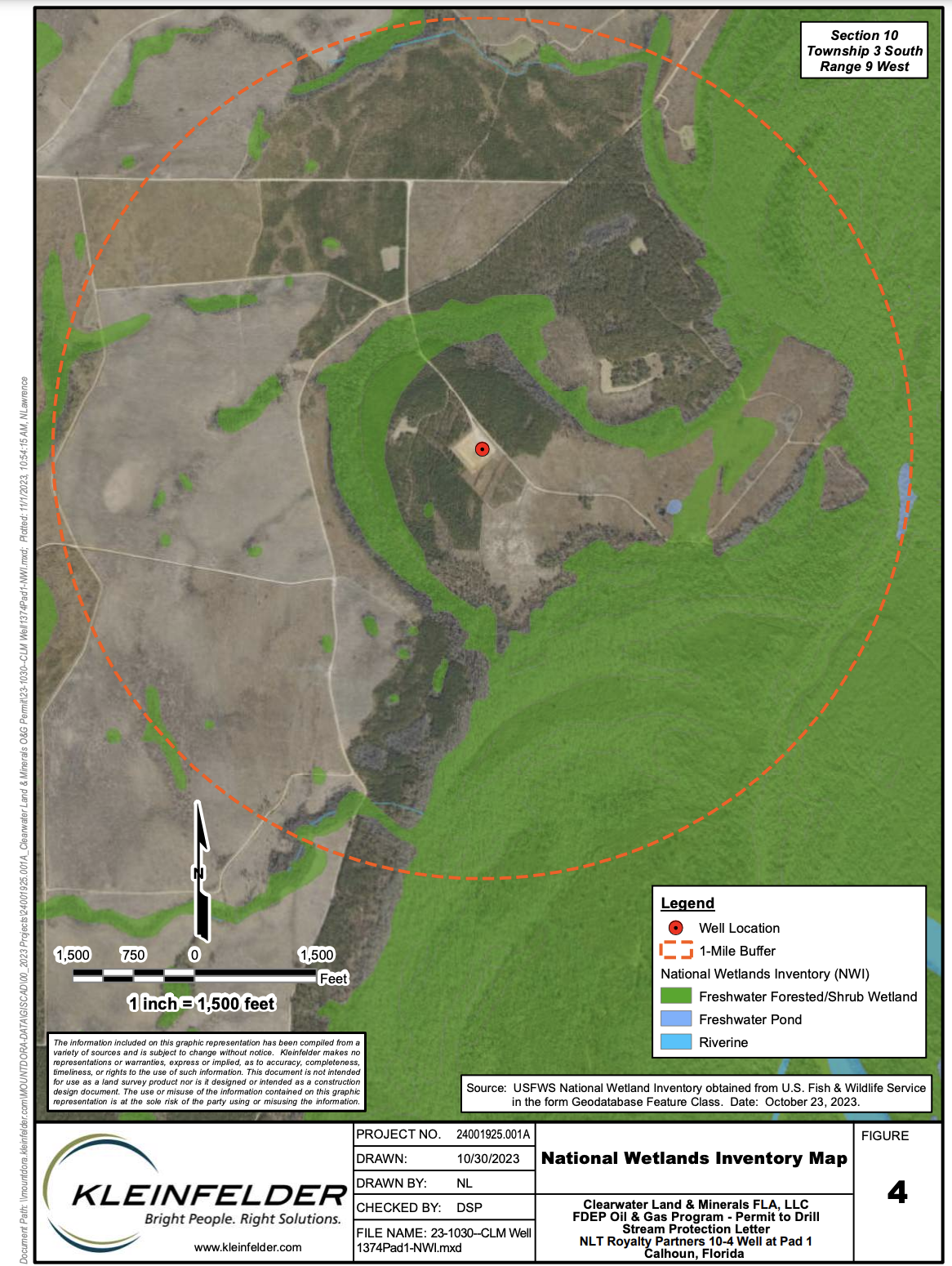
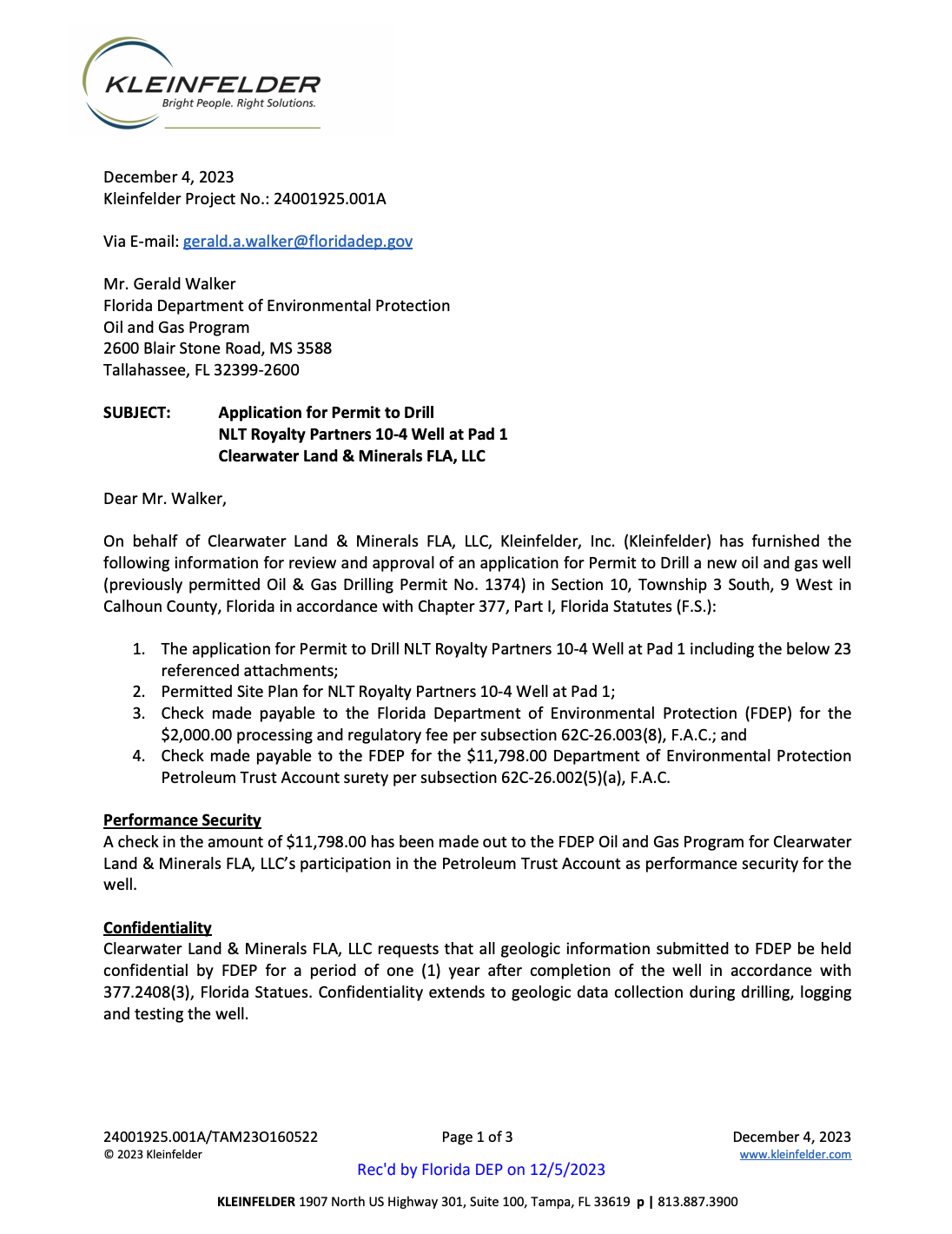
Clearwater Land & Minerals submitted an application to the Florida Department of Environmental Protection for a permit to drill an exploratory oil and gas well (at a site previously permitted to the Cholla Company*) in Calhoun County. Exploratory drilling is an attempt to find commercially viable crude oil. This drilling site is located in the floodplain of the Apalachicola River, between the Chipola River, Dead Lakes, and the Apalachicola River. A decision by FL DEP is expected by April 29, 2024.
Now is time to to contact FL DEP. This “wildcat” exploratory oil and gas well should not be located in the Apalachicola River floodplain. Please email concerns or questions to DEP Administrator, Mr. Gerry Walker, [email protected] Include your contact information (name and address) with your email.
Concerns include:
- This drilling site is located in the floodplain of the Apalachicola River, a designated Outstanding Florida Water.
- The drilling area is surrounded by wetlands and freshwater forest.
- Exploratory drilling bring the risk of releasing harmful chemicals into the wetlands and rivers, threatening recreational and commercial fishing, and aquatic habitat.
- Oil and gas drilling require thousands of gallons of water per day, water that would otherwise support flows to the Apalachicola River, its floodplain, and the Apalachicola Bay.
- Upstream drilling puts the Apalachicola Bay at risk when millions of state funds (tax dollars) are focused on the restoration of oyster reefs.
- This well is not in the public interest for those that use and care for the Apalachicola River and Bay. The risk of damage to water quality, and the biological and geological integrity of the ecosystem from oil drilling far exceeds any benefits that a small number of property owners and an oil company will gain.
- Extreme weather events are expected to worsen flooding in years to come.
Click here to review Application for Permit to Drill
Related news
‘A big price’: Oil drilling application in Florida Panhandle prompts environmental outcry
Oil and Rivers Don’t Mix, by Cameron Baxley, Op Ed, Apalachicola Times
An oil company could start drilling in the Apalachicola River Basin, WFSU
Below is an excerpt of formal comments submitted to the FL DEP by Apalachicola Riverkeeper.
The Apalachicola River is the largest river in volume in Florida and has the largest and most
environmentally sensitive undisturbed floodplain ecosystem in the state. That central feature of
the river system is confirmed by the legally recognized status as an Outstanding Florida Water
in 1984. Outstanding Florida Waters are a special category of water body set out by section
403.061(27), Florida Statutes. They are waters designated worthy of special protection because
of their natural attributes that are of an ecologically outstanding character. For that reason,
permits for activities that would degrade them must meet a stringent test – that construction
must be “clearly in the public interest.”
This site is located within the Apalachicola River floodplain and close to flowing river waters
during normal high flows, such as those in winter months. At those times, about ninety-five
percent of the Apalachicola River floodplain is connected aquatic habitat. Moreover, during
major flood events, the drilling pad would be surrounded by flowing water.
The Apalachicola River is also connected at high flows to the source of drinking water supplies
for the city of Port Saint Joe. Oil drilling and production in the floodplain of any river of this
character risks catastrophic damage to the river system.
The Apalachicola River’s extensive forested floodplain contains a diverse assortment of aquatic
and wetland habitats. About 60 species of trees occur in the bottomland forest of the
Apalachicola River floodplain. Mixed bottomland hardwoods are dominated by water hickory,
sweetgum, overcup oak, green ash, and sugarberry, and grow in the areas of higher elevation in
the floodplain (levees, ridges, and flats). Tupelo-cypress forested wetlands, also called swamps,
grow in depressions and areas of lower elevation. Some of these swamps are covered with
standing water year-round; others are inundated much of the year but lack standing water
during the driest months.
Streams, sloughs, ponds, lakes, and swamps in these floodplains are alternately connected and
disconnected from the main river channel as river levels fluctuate. Complex relationships exist
between biological communities in floodplain habitats and river flow, with floral and faunal
distributions varying spaDally, seasonally, and annually. During low-flow periods, shallow
waters in the flood- plain provide refuges for fishes from the deep, swiftlly flowing waters of the
main channel. During flood events, fishes use inundated floodplain forests for food, protective
cover, spawning sites and nursery grounds.
As a result, the Apalachicola River’s floodplain has the highest species diversity of reptiles (over
80 species) and amphibians (over 40 species) found north of Mexico. It also provides habitat for
more than 280 species of birds, over 130 species of fish, over 52 species of mammals, and over
1,300 species of plants – including over 70 different species of trees. Among these species are
more than 30 federally threatened or endangered animal species. Listed, rare, threatened,
endangered and otherwise imperiled species in the floodplain include Gulf sturgeon, striped
bass, spoRed bullhead, five species of mussels, Apalachicola dusky salamander, eastern indigo
snake, Florida manatee, bald eagle, swallow-tailed kite, Mississippi kite, Barbour’s map turtle,
and the fox squirrel. Nearly the enDre river floodplain is identified by the Florida Natural Areas
Inventory as priority rare species habitat.
… .the Clearwater project bases its “likelihood” through analogy with the nearest oil
fields that are about 125 miles away in Jay, Florida. For reference, the historical failure rate of
wells drilled in Calhoun County and adjacent Gulf, Gadsden, Franklin, Liberty, and
Washington counties is 100% (70 dry holes out of 70 wells actually drilled).
_________________________________________________________________________________________
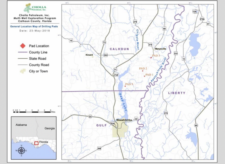
*BACKGROUND ON PREVIOUS CHOLLA PERMITS* in Calhoun County (2018-2020)
January 2 2022– The 6 oil and gas drilling permits issued to Cholla Petroleum by FLDEP have expired. No drilling activities have occurred to date. It is not anticipated that new permits will be sought. Apalachicola Riverkeeper will continue to monitor oil and gas prospecting in the Apalachicola River Basin.
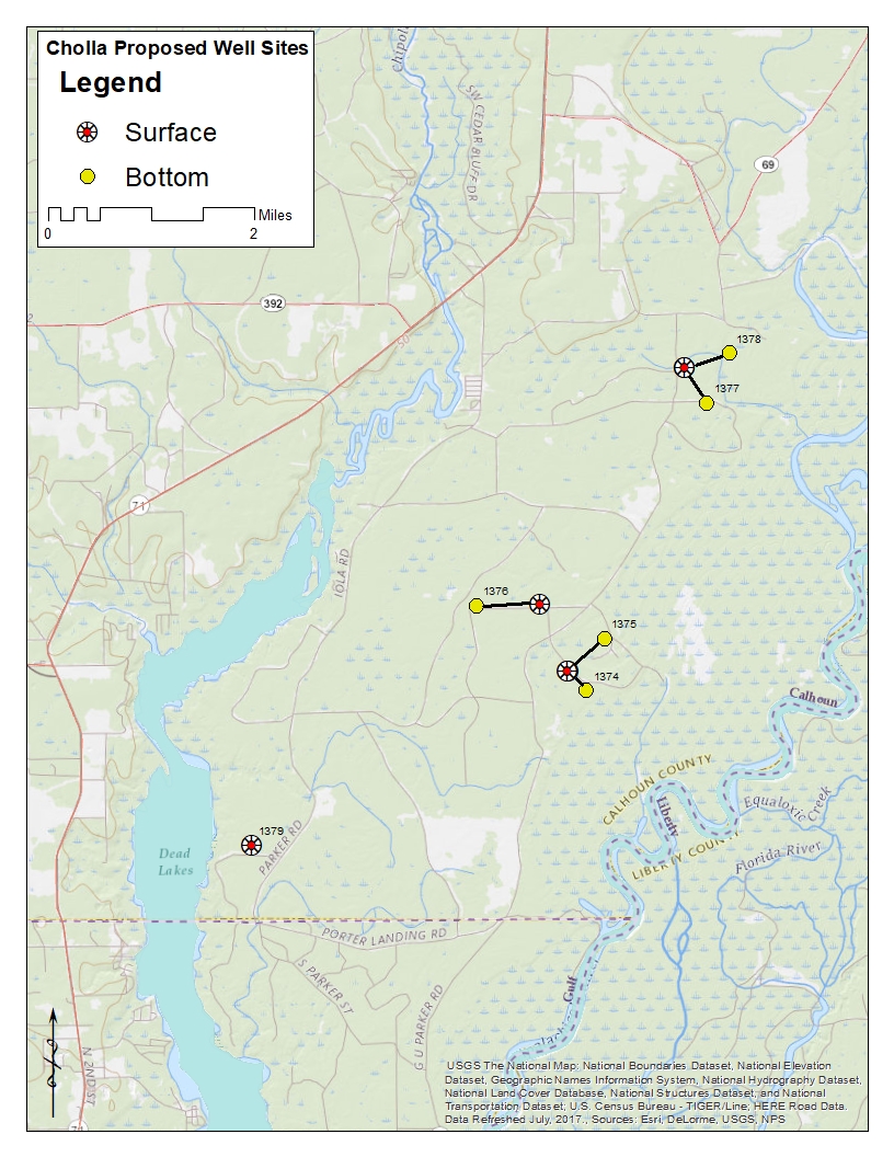
Monday, March 15, 2021–Cholla Petroleum of Dallas, Texas has begun site construction for exploratory oil and gas drilling in the Apalachicola River floodplain of Calhoun County. The two pads are permitted for two wells each. A total of six wells are permitted (four pads total). The permits were initially approved in December 2019 by the state and February 2020 by Calhoun County. Both have a role in the permit process.
Apalachicola Riverkeeper remains strongly opposed to these exploratory oil & gas wells as they pose significant ecological along with economic risk to the region. We will continue to monitor the permit activities and address concerns with residents, local and state officials.
 Six exploratory oil and gas wells are permitted to Cholla Petroleum. The wells will be located between the Chipola River, Dead Lakes and the Apalachicola River. These applications were first submitted in August 2018, prior to Hurricane Michael. ARk’s Comments of Opposition submitted to FL DEP.
Cholla’s drilling pads will be located within the Apalachicola River basin and close to flowing river wate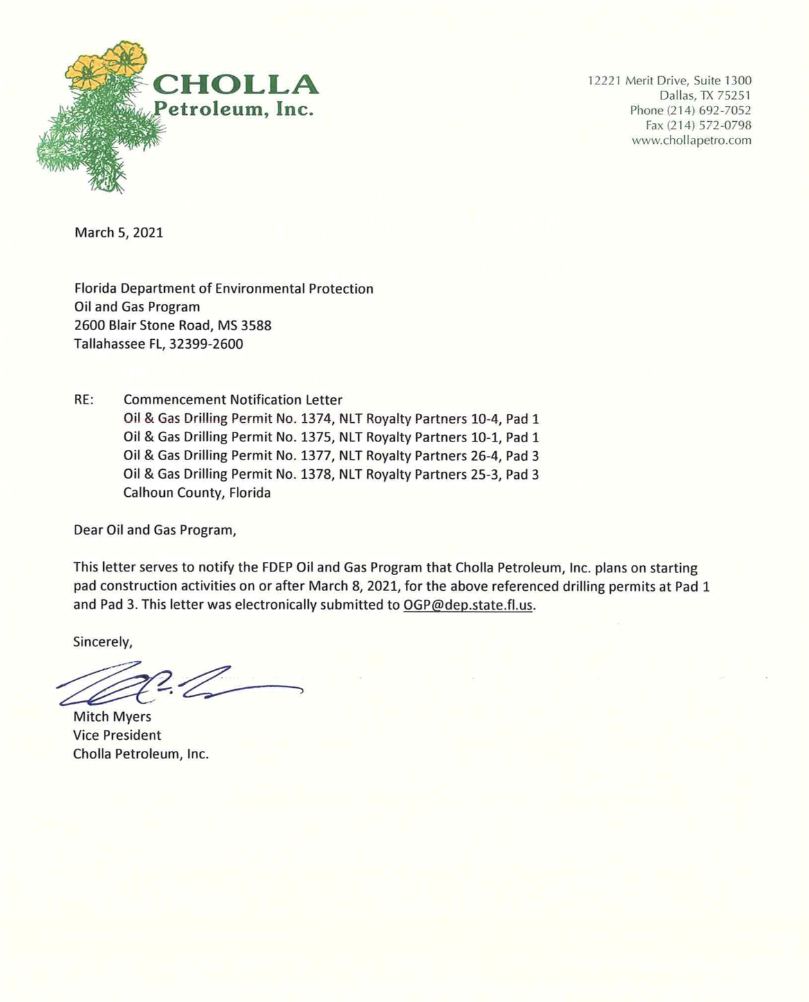 rs during normal high flows. At those times, ninety-five percent of the Apalachicola River floodplain is connected aquatic habitat. Moreover, during major flood events, the drilling pads would be surrounded by flowing water. Of additional concerns are PSJ’s drinking water supply (that comes off intake canal from Chipola River) and the potential construction of a hydrogen sulfide processing plant if a commercial oil field is then pursued. Downstream communities could be affected.The risk of damage to water quality, biologic and geologic integrity of the ecosystem from oil drilling far exceeds any benefits that a small number of property owners and an oil company will gain. These wells are not in the public interest for those that use and care for the Apalachicola River and Bay.
 Cholla Petroleum proposes to drill 12,900 feet down, punching through the Floridan aquifer, the source of drinking water for much of Florida. Both surface and groundwater serve as primary sources of water to Apalachicola Bay and the Gulf of Mexico in our region. Protection of these water sources is of tremendous importance to the human health, wellbeing, culture and economy of the Apalachicola River region. The development of oil and gas in this area threatens the basic quality of life due to the high risk of pollution of the surface and groundwater, subsidence of coastal plain, air quality, and community character.
More than 40 species of amphibians and 80 species of reptiles live within the Apalachicola River basin, the highest diversity of amphibians and reptiles in the United States and Canada. More than 1,300 species of plants, including 103 that are threatened or endangered, are also found in the Apalachicola basin.
Exploratory wells bring the risk of releasing harmful chemicals into the wetlands and rivers. A period of heavy rain could be disastrous if it carries toxins into the river system. Oil wells also require thousands of gallons of water per day, water that would otherwise support flows to the river, floodplain and bay.
If Cholla discovers commercially viable oil, a separate phase of permits through Florida DEP is required for drilling.
Public records related to the permit are available by contacting DEP’s Oil & Gas Program. Current oil permit applications can be found HERE. Questions and comments can also be addressed to FL DEP HERE , Tallahassee office.
Individuals and groups opposed to this exploratory oil and gas drilling can contact DEP Oil & Gas Program
- DEP Oil & Gas Program Administrator Cindy Mulkey [email protected]
- On email, copy the DEP Office of Ombudsman-Public Services [email protected]
- On email, copy your state representative For many it is Mr. Jason Shoaf jason.shoaf@
myfloridahouse.gov Mr. Shoaf represents Calhoun, Franklin, Gulf, Jefferson, Lafayette, Liberty, Madison, Taylor, Wakulla and part of Leon. - On email, copy state Senator Loranne Ausley [email protected] Sen. Ausley represents Calhoun, Franklin, Gadsden, Gulf, Hamilton, Jefferson, Leon, Liberty, Madison, Taylor and Wakulla counties.
- Jackson County residents, copy Senator Gainer gainer.george.web@flsenate.
gov - Please also consider cc’ing your county commission member if residing in the Apalachicola River Basin.
Cholla Petroleum previously conducted seismic testing in Calhoun County in 2016. Related in Spring 2018, Spooner Petroleum drilled an exploratory well in Calhoun County. It came up “dry.”
To keep informed on this issue, please join our mailing list.
To support our continued work to monitor and address oil & gas drilling threats, please donate today.
“Oil Company Builds Drilling Platform at Florida Floodplain Despite Environmental Warnings,” Newsweek, March 19, 2021
“Petroleum Company Begins Building Drilling Platforms in Apalachicola Floodplain,” Tallahassee Democrat, March 18, 2021
“Preparations Underway for Exploratory Oil and Natural Gas Drilling in Calhoun County,” WFSU, March 18, 2021
******************
June 2021 Spooner’s Bear Creek Well in Gulf County comes up “dry.”
Spooner Petroleum was permitted for one well in Gulf County, Bear Creek well. The application was submitted to FL DEP by Spooner Petroleum in July 2019. The proposed well will be drilled in the Wetappo Creek watershed basin in Gulf County. Apalachicola Riverkeeper submitted comments of opposition to FL DEP to this permit application. On December 2, 2019, DEP Issued a Final Permit to Spooner for the Bear Creek well. Site construction in underway.
****************
Tuesday, February 18, 2020–The Calhoun County Planning Commission and the Board of County Commissioners voted to approve (4-1) land use permits for 6 exploratory oil and gas wells to be drilled by Cholla Petroleum of Dallas, Texas on land owned by Neal Timber. The meetings were held back to back and the commission members of both bodies are the same. Thank you to Chairman Monlyn for voting nay.
No residents spoke in favor of the drilling, while 15-20 citizens in attendance were opposed to the permits for oil and gas drilling. Several residents voiced their concerns at the first meeting, the Planning Commission. Their comments were then entered into the public record as part of the second meeting, as explained by the County Attorney. Concerns expressed by residents included infrastructure impact (such as county roads), high water around the drilling areas, water supply safety and lack of information on potential economic impact.
Georgia Ackerman of Apalachicola Riverkeeper also addressed both commission meetings, reading a prepared statement (attached below). Apalachicola Riverkeeper, other conservation organizations and the City of Apalachicola filed comments of opposition to Cholla’s permits with the Florida Department of Environmental Protection Oil and Gas Program. Many residents of the Apalachicola River region also wrote letters of concern to the state. (These letters are part of the state’s public records).
Cholla applied for the 6 permits with the state in September 2018. The County is involved with the local land use permitting for drilling. During the Planning Commission meeting at 3:30 pm, an attorney for Cholla Petroleum provided a short overview of permits. A display of location sites also was made available. A few questions were asked by the commissioners. One question confirmed that 56 truckloads would deliver the drilling equipment to Blountstown. The minutes of the meeting are available through the Clerk of the Court’s office.
If Cholla discovers commercially viable oil, a separate phase of permits through Florida DEP is required for drilling. It is expected that the crude will be transported to refineries west of the County for processing. In the event of commercial production, the County would receive a percentage of a severance tax. “Hard to say how much” as described by the attorney for Cholla Petroleum.
*****************************************
February 18, 2020
Dear Mr. Chairman and Members of the Commission,
Attached please find Apalachicola Riverkeeper’s comments of opposition to Cholla Petroleum’s permit request for 6 exploratory oil and gas to be located in the Apalachicola River floodplain between the Dead Lakes, the Chipola River and the Apalachicola River. These comments were submitted to DEP’s Oil and Gas Program in December 2018. You may also recall, these comments were provided in hard copy to Commission Members. I urge you to review them.
Cholla Petroleum plans to drill both vertically (straight down) and directionally (at an angle) 13,000-14,000 feet through the aquifer in search of commercially viable oil and gas. The six proposed oil and gas exploration wells would be constructed on four drilling pads that would be located between the main thread of the Apalachicola River and Dead Lakes. Each of the drilling pads would occupy approximately three acres and be surrounded by berms piled up from materials excavated on the site to form a storm water percolation pond.
One of the drilling sites will be about 2,000 feet from the Dead Lakes. Please study each proposed site carefully. I’d also urge you to go visit them, especially the northern most site and the site near Dead Lakes.
This past week, the Apalachicola River was flowing around 100,000 cfs.
And, the Chipola River was flowing over 3,000 cfs.
Excerpted from FWC’s comments on the permits when filed in 2018 (highlights added):
“The applications contain site contingency plans proposed in the event of a major storm or flooding. The applications indicate steps that will be implemented during “extraordinary events” such as floods, tropical storms, and/or hurricanes. It is not clear from the applications if the sites are above the elevation that could be flooded during major floods of the Apalachicola and on the Chipola River/Dead Lakes. Major flood events are those events of 150-266,000 cubic feet/second (cfs) on the Apalachicola River and 1500-4850 cfs on the Chipola River/ Dead Lakes. These events have occurred five times over the past 15 years and are expected to occur more frequently. Extreme inundation of pads caused by these events may overcome the planned “500-year storm event plans” for the stormwater and berm areas as well as inundate the existing road network that would be used for moving material to higher ground. The long-range weather forecasts include these values as possibly occurring over the next six to nine months, which corresponds to the proposed drilling timeline. The accidental release of fuel, crude oil, chemicals, drilling fluids and hazardous materials could impact fish and wildlife resources in the floodplain. While we understand that an accident is a limited possibility during this exploratory phase, FWC staff requests that these factors and the higher inundation potential for the pads, berms, and road network be considered as part of the site contingency plans.”
In addition to drilling machines and generators, tanks of chemicals to mix drilling mud, hydrochloric acid, drilling mud containment vessels and fuel tanks would all be on the sites. The amount of drilling mud stored on the site would be sufficient to drill over 2 miles below the surface of the ground.
The risk of a blowout is real. The risk of a big spill is real. As we approach the 10-year anniversary of the Deepwater Horizon spill in the Gulf, please recognize that the dangers of onshore drilling are similar to offshore. The damage from the DH spill will never be undone.
Similarly, smaller spills occur in production and transport. You may recall the oil spill data I shared related to the Jay Oil fields when Spooner Petroleum applied for a drilling permit. These incidents may not make headlines, but spills of oil and related contaminants are a component of drilling.
If commercially viable crude is discovered, what mode of transportation will be utilized to carry it to refineries to our west? Tanker trucks? Pipeline? Barges?
Also, as indicated in our comments to DEP, the city of Port St. Joe’s drinking water comes from an intake canal on the Chipola River, 30-35 miles downstream.
And as we are all aware, the Chipola and Apalachicola Rivers connect and drain to the Apalachicola Bay then further into the Gulf of Mexico.
The economy and ecology of the Apalachicola River basin, including the residents of Calhoun County and downstream communities, should not be put at risk by the dangers of oil and gas drilling. We should all be working together to protect the Apalachicola River basin for generations to come. Please deny these permits.
Thank you for your consideration. I’d gladly discuss this in further detail.
Respectfully,
Georgia Ackerman
Riverkeeper
Apalachicola Riverkeeper