The P/Z hearing room was full. Public comments were vigorously opposed to the advancement of the Landing development and came from attorneys, charter captains, seafood workers, homeowners, long-term residents and newer ones, environmentalists, retirees, and more. Concerns ranged from the impact the development inevitably would have on Apalachicola Bay, to concerns over affordable housing, traffic planning, and indications that the proposed site planning and amenities are intended for a far denser development than what is disclosed in the existing pitch materials.
The planned presence of a fuel dock as part of the marina component of the project became an issue for many, particularly since any mention of this potential environmental hazard is absent from the developer’s pitch packet. Representatives for the developer openly admitted that, while a fuel dock is planned as part of the marina component of the project, the engineering and plan for fuel storage is yet to be determined and, in fact, many similar questions remained to be answered.

 If this development leads to its closure due to poor water quality, there will be negative impacts from an ecological and fishing perspective. Salt marshes and seagrass are some of the most biologically productive natural communities known. They serve as shelter or nursery grounds for many invertebrates and fish. These habitats serve as important food sources for manatees, marine turtles, recreational and commercial marine species such as mullet, blue, oysters, and shrimp. The smaller minnows and juvenile fish also provide food for many recreationally important fish, such as tarpon, flounder, red drum, and spotted sea trout. They also improve our water quality by slowing down water runoff and filtering pollution. These natural resources assist in erosion control by reducing the wave-energy on the bottom and promotes settling of suspended particulates. The settled particles become stabilized by the dense roots and rhizomes.
Rebecca Jetton reviewed the site plan for consistency with the Franklin County comprehensive, “comp,” plan. She explained that the bungalows were in the wetlands instead of setting back 50 feet. The parcel contains acreage in the one hundred year floodplain. No fill is allowed in this area, however the applicant intends to place fill in this area. If the county approves the development, the community planning act requires the applicant to mitigate by donating land to remain vacant or contribute funding for hurricane resiliency or evacuation. The applicant has a DEP permit to conduct a maintenance dredge although no dredging has occurred in 30 years. The applicant does not have an active permit from the Army Corps of Engineers.
The dredging and boat traffic will require a breakwater. The breakwater will preclude public access on the beach which is also a requirement of the comp plan.
The applicant has requested a Planned Unit Development (PUD) however the County has no criteria in the code for a PUD. Density in the one hundred year floodplain is one unit per acre. She pointed out the need for clarity regarding the Density across two different zones. One allows 80 percent lot coverage and the other is one unit per acre. Information is needed regarding whether the single family units will be short or long term rental.
The comp plan prohibits fill in salt marsh and prohibits the destruction of sea grasses. The channel contains sea grass.
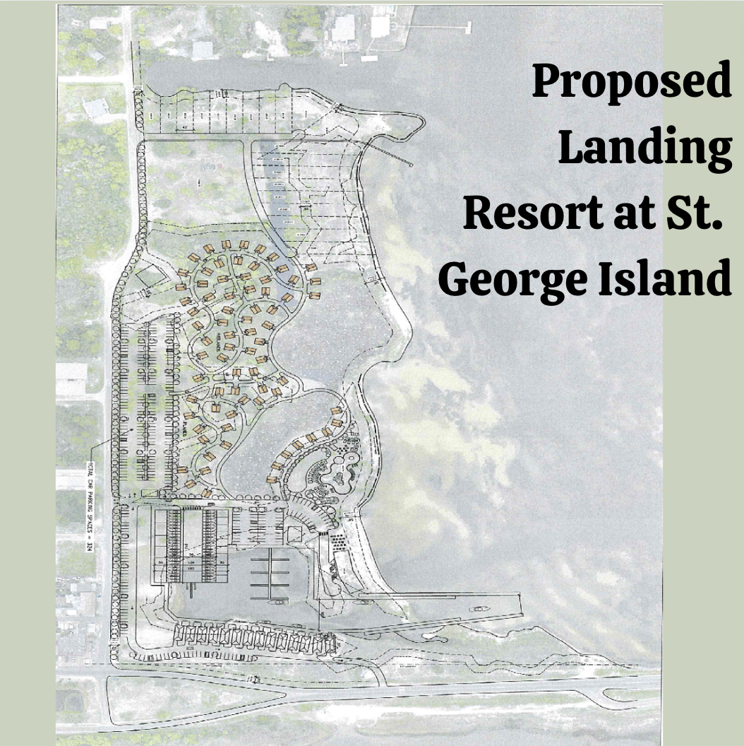
The previoulsy proposed development at St. George Island included the following: 
- Dwelling units (hotel, short term rental and single- family units) with hotel bungalows constructed over wetlands instead of fifty feet from wetlands*
- Dry stack boat storage
- Wet slips with sewer pump out
- Increased nutrients to bay from wastewater disposal and stormwater
- Maintenance dredge of channel containing sea grasses from boat basin to intracoastal waterway; not dredged since 1980
- New dredging and maintenance dredging of boat basin which may have poor circulation and flushing
- Spoil disposal on site within floodplain
- A breakwater/ revetment to prevent erosion resulting from boats using channel
- Requires fill in surface water for dry stack boat storage and in existing canal
- Requires fill in wetlands
- Eliminates access to beach for public access due to location of breakwater/revetment
- Requires a water quality monitoring plan
- Requires wetland mitigation at 2 to 1 ratio